
Lines9 lines
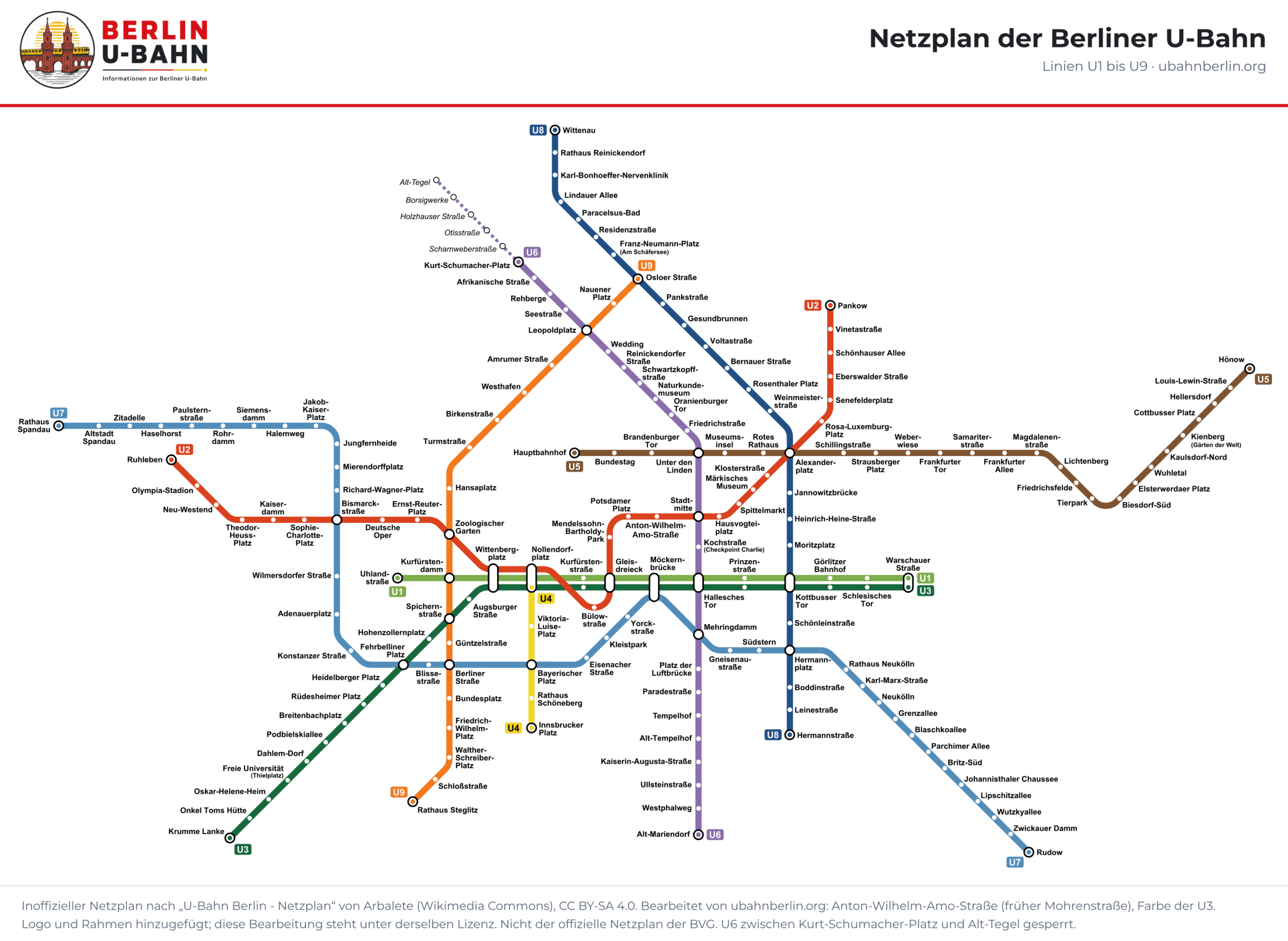
All nine lines and 175 stations on one map. Tap to enlarge or download it as a PDF.
Berlin U-Bahn map · PDF
Vector PDF: stays sharp when you zoom in. Save it on your phone in case you have no signal on the way.
Map: after “U-Bahn Berlin – Netzplan” by Arbalete (Wikimedia Commons, CC BY-SA 4.0), edited by ubahnberlin.org (station name Anton-Wilhelm-Amo-Straße updated, colour of the U3 corrected). This edited version is also licensed under CC BY-SA 4.0.
Each line has its own colour, the same on the map, in the stations and on this page. Capsules and white circles mark interchanges. The map is a diagram, not a street map: distances are not to scale.
The section of the U6 between Kurt-Schumacher-PlatzDE and Alt-TegelDE is drawn dotted, with hollow circles and grey names, because it is closed. There are no walking links between two different U-Bahn stations that count as a change in the timetable; you can only change trains within a station.
| Line | Stations | Route in service |
|---|---|---|
| U1 | 13 | Warschauer Straße – Uhlandstraße |
| U2 | 29 | Pankow – Ruhleben |
| U3 | 24 | Warschauer Straße – Krumme Lanke |
| U4 | 5 | Nollendorfplatz – Innsbrucker Platz |
| U5 | 26 | Hönow – Hauptbahnhof |
| U6 | 29 | Kurt-Schumacher-Platz – Alt-Mariendorf |
| U7 | 40 | Rathaus Spandau – Rudow |
| U8 | 24 | Wittenau – Hermannstraße |
| U9 | 18 | Osloer Straße – Rathaus Steglitz |
100 U-Bahn stations are in fare zone A (the city centre up to and including the S-Bahn Ring), 75 in fare zone B (outside the Ring up to the city boundary). No U-Bahn station is in zone C, so a Berlin AB ticket covers every U-Bahn journey. Each station page gives its fare zone; fares are listed under Fares.